Short upper Mustang trek Overview
The Short Upper Mustang Trek (15 Days) is an unforgettable journey through Nepal’s Trans-Himalayan region, where ancient Tibetan culture and history remain beautifully preserved. Nestled within the Annapurna Conservation Area, this short trek follows the legendary Kali Gandaki River, leading to the breathtaking walled city of Lo Manthang. With its centuries-old Buddhist monasteries, dramatic landscapes, and rich Tibetan heritage, this adventure offers a truly unique experience.
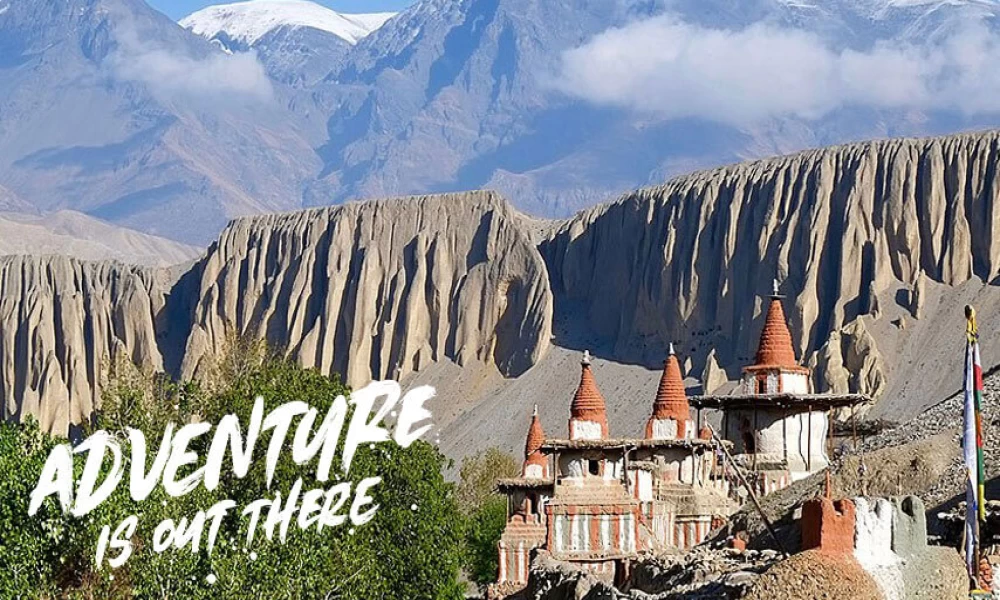
The name Mustang comes from the Tibetan term Mun Tan (smon-thang), meaning "fertile plain." Once known as the Kingdom of Lo, it is now part of Nepal’s Mustang District, located in the north-central region, bordering Tibet. The Kingdom of Lo, traditional Mustang, and Upper Mustang all refer to the same region, covering the northern two-thirds of the present-day Mustang District. Often called the "Last Forbidden Kingdom" and the “Kingdom behind the Himalayas,” Upper Mustang showcases a diverse landscape, from rugged cliffs to vast barren plains.
Travelers can spot the official "Mustang" border signs just north of Kagbeni, where a checkpoint verifies permits for non-Nepalese visitors. Another checkpoint is located at Gyu La Pass, east of Kagbeni. The people of Mustang, known as Mustangis, follow Tibetan Buddhism, preserving their deep-rooted cultural traditions.
Why Choose the Short Upper Mustang Trek?
If you seek an adventure filled with culture, nature, and history, the 15-day Short Upper Mustang Trek is perfect. Unlike other treks in Nepal, this short trek to Lo Manthang takes you deep into a Tibetan-influenced world, still largely preserved from the outside world. The ancient monasteries, historic landmarks, and the Tibetan Plateau make this short Upper Mustang trek journey a truly unforgettable experience in Nepal.
What You'll Experience in this Short Upper Mustang Trek
- Rich Tibetan Culture: Immerse yourself in the unique blend of Tibetan Buddhist traditions that define the region.
- Scenic Landscapes: Explore the rugged Himalayan desert, the Kali Gandaki River, and the vast Tibetan Plateau.
- Less Crowded Trek: Unlike other treks in the Annapurna Region, this route offers a more secluded and tranquil experience.
- Majestic Monasteries: Visit famous monasteries like Thubchen Gompa and Ghar Gumba, each showcasing stunning architecture and spiritual significance.
- The Kingdom of Lo: Discover the ancient walled city of Lo Manthang, the heart of Upper Mustang, and the kingdom's 5-storey royal palace.
- Sky Caves: Explore the fascinating sky caves and ancient dwellings carved into cliff faces, offering a glimpse into the region’s mysterious past in this Short Upper Mustang Trek.
- Unique Festivals: Experience the vibrant Tiji Festival, with its lively rituals and colorful masked dances.
Short Upper Mustang Trek Difficulty and Altitude
The Short Upper Mustang Trekking is moderately complex, with challenges such as high altitude (Lo Manthang at 3,840m) and rugged terrain. Altitude sickness prevention and proper acclimatization are essential for a safe trek.
- Highest Altitude: Lo-Manthang (3,840m)
- Altitude Sickness Risk: Proper acclimatization is essential.
- Weather Challenges: Cold temperatures and strong afternoon winds.
- Terrain: Mostly arid, dusty paths with some steep ascents.
Best Time to Trek Upper Mustang Region
The Mustang region differs from other trekking routes in Nepal because it lies in the rain shadow of the Annapurna Himalayas, making it trekking-friendly year-round, even during the monsoon season.
- Spring (March-May): Enjoy clear skies, beautiful blooming landscapes, and mild temperatures.
- Monsoon (June-August): Trekking is still possible because of the region’s rain shadow.
- Autumn (September-November): The weather is stable, and the mountain views are breathtaking.
- Winter (December- February): The weather can be harsh with snow, but you'll encounter fewer trekkers to trek in the short Upper Mustang route.
Accommodation During the Short Upper Mustang Trek
Lodging in the Short Upper Mustang trek is basic but offers an authentic experience. Most lodges have twin-sharing rooms with shared toilets, while some offer attached bathrooms for an extra cost. Carrying a sleeping bag and warm clothing is recommended due to cold nights.
Food & Dining in Short Upper Mustang trek route
Meals are simple yet delicious, with dishes such as rice, noodles, soups, and lentils. Tea, coffee, and a cozy fireplace in some lodges add to the experience.
Key Tips for Short Upper Mustang Trekking:
- Costs are higher due to the region’s remoteness—carry cash.
- Bring a water filter and avoid plastic bottled water, which is expensive.
In short, while facilities are limited, the warm hospitality, local cuisine, and unique tea house experience make the stay in Upper Mustang memorable.
Alternative Upper Mustang Jeep Tour Package
If you're short on time but still want to experience this incredible journey, A1 Excursion offers a well-planned 10-day Upper Mustang Jeep Tour as an alternative to trekking. This tour starts and ends in Pokhara, allowing you to explore the breathtaking landscapes of Mustang comfortably.
Click here to learn in detail about the Upper Mustang Jeep Tour.
Book Your Short Upper Mustang Trek -15 Days with A1 Excursion Adventure
Discover the wonders of Upper Mustang with A1 Excursion Adventure! Our experienced guides, well-planned itineraries, and top-notch service guarantee an unforgettable journey through stunning landscapes and the rich Tibetan culture.
Don't Miss Out! 🚙✨ Reserve your Mustang region Trek with A1 Excursion Adventure today and embark on an unforgettable journey through the hidden kingdom of Mustang. 🌄🏔️
For bookings, inquiries, or to learn more about the Short Upper Mustang Trek cost, feel free to contact A1 Excursion Adventure. Let’s make your adventure in Nepal a reality!